
FURTHER ELABORATION ON THE EXTENT AND GEOGRAPHICAL SETTING OF THE MANOR
The description of the manor in the 1609 document is reasonably clear, with the exception of the south of the area, and here I have had to use my best judgement. I searched for a map of the manor of Barton in the major archive sources in this part of the Midlands and in London, including the Duchy of Lancaster, but without success. This does not mean that one will not be found, but in the meantime I have tried to do the best I can with what is immediately available.
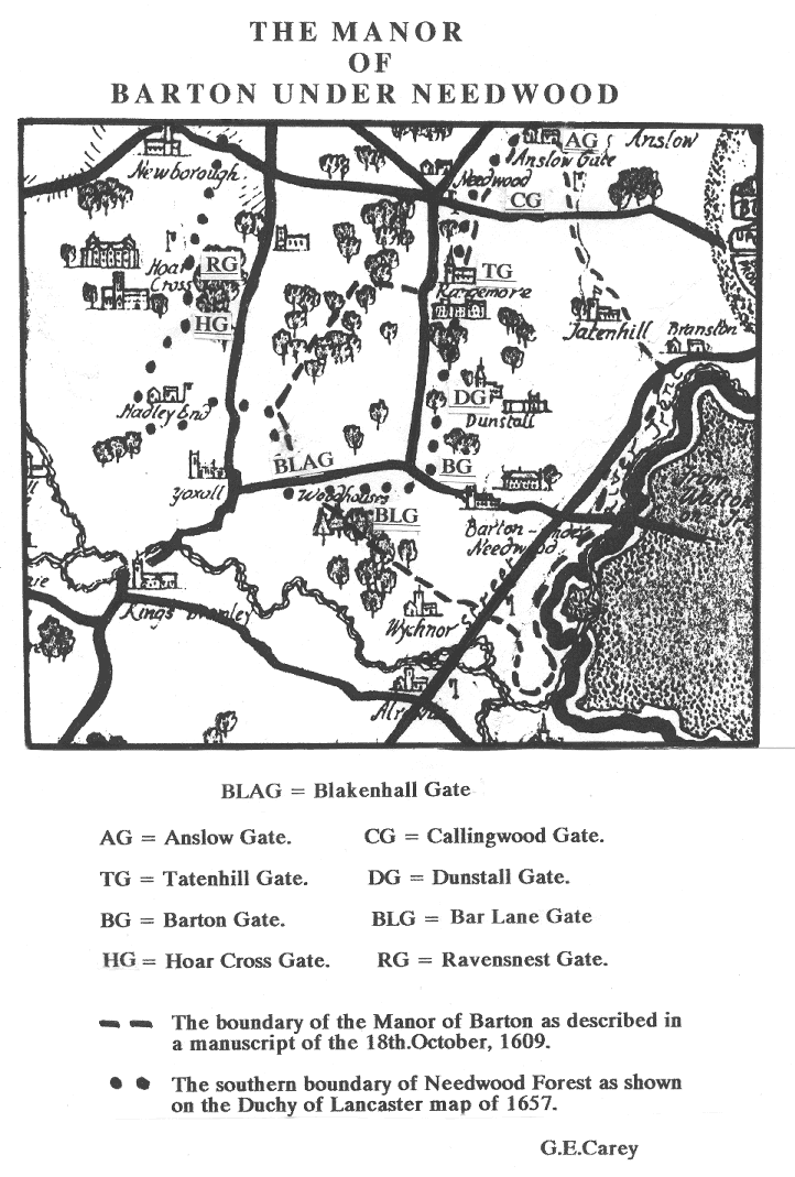
The manor boundary starts west of Catholme and runs southeast to the River Trent. The wording ‘beginneth and boundeth upon the Lordshipp of Whichnor’ would seem to indicate that the boundary of the Lordship is to be followed and that the village itself is not touched. This route coincides with the boundary of Barton shown on the 1839 Tithe Map.
Having reached the Trent, we follow the river downstream to a point called Redbrincke. I cannot find this on any maps I have to hand, but the fact that the boundary continues northwest to Gallowe Bridge, (where the A 38 crosses a small stream near the approach to Branston Water Park), helps us to locate Redbrincke fairly accurately. This stream must be the one referred to as Balkes Brook. We follow its course upstream keeping east of Tatenhill Church, passing under School Bridge, and taking the northerly tributary to Rough Hay (Rowhey). Skirting round the border of Anslow (Annsley) we arrive at the edge of Needwood Forest at, or near to, Anslow Gate (one of thirty two forest gates). The account now tells us to travel south west to Tatenhill Gate, (really Rangemore) keeping to the forest boundary, and in doing so we must pass Callingwood Gate.
From Tatenhill Gate we enter Needwood Forest, proceeding westwards to the point where Byrkley Lodge (Brickley Lodge) used to be, just west of Byrkley Gardens. This short stretch is part of what was an important forest track running right across to Ravensnest Gate on the other side of the forest, (between Jackson’s Bank Wood and the Meynell Arms). This was called Aylewardsly Way and it was an important link between Burton and Abbots Bromley. It also served to separate the Tutbury Forest Ward to the north from Yoxall and Barton Forest Wards to the south.
Having reached a point near Byrkley Lodge, we meet a small stream, the Lin Brook, which is a tributary of the River Swarbourne. Keeping to the course of this stream we cross the Scotch Hills Road and continue until we reach Stonyford. The Lin Brook formed the boundary between two wards of the forest, Yoxall Ward (to the west) and Barton Ward (to the east). Our route now takes us along the edge of the forest, by way of Sich Lane, to Woodhouses, (on the Barton Gate to Yoxall Road).
Leaving Needwood Forest behind us, we travel along the western edge of the Blakenhall estate, on the line which divides Blakenhall from Wychnor, until we come to the point near Catholme where we started.
It will be clear from this and the accompanying map, that the Manor of Barton was a very large area, including Dunstall, Tatenhill, Rangemore, and Callingwood, as well as Barton itself. Barton Forest Ward constituted about twenty five per cent of the area of Needwood Forest and all of the ward lay within the Manor of Barton. (The total area of Needwood Forest was 9,220 acres, 1 Rood and 8 Perches).
With regard to the population of the manor, all we have to go on is a note recorded when Dr.Adrian Saravia was the Rector of Tatenhill (1588-1595) which gives the number of households in Barton as eighty six and those for Tatenhill as seventy seven. The situation is unlikely to have changed much by 1609.
Geographically, the manor is very varied. The area around Callingwood rises to an elevation of about one hundred and forty metres above sea level, whereas in the south east around Catholme there are elevations of fifty metres or less. A lobe of high ground running south from Callingwood to Barton Gate causes the drainage to be either east to the Trent or southwest to the Swarbourne. The Needwood plateau is fairly well dissected by streams, as illustrated by the Scotch Hills road switchback. The higher ground is formed of the reddish Keuper Marl, capped here and there by glacial material, but this gives way to gravels and other alluvial deposits in the Trent valley.